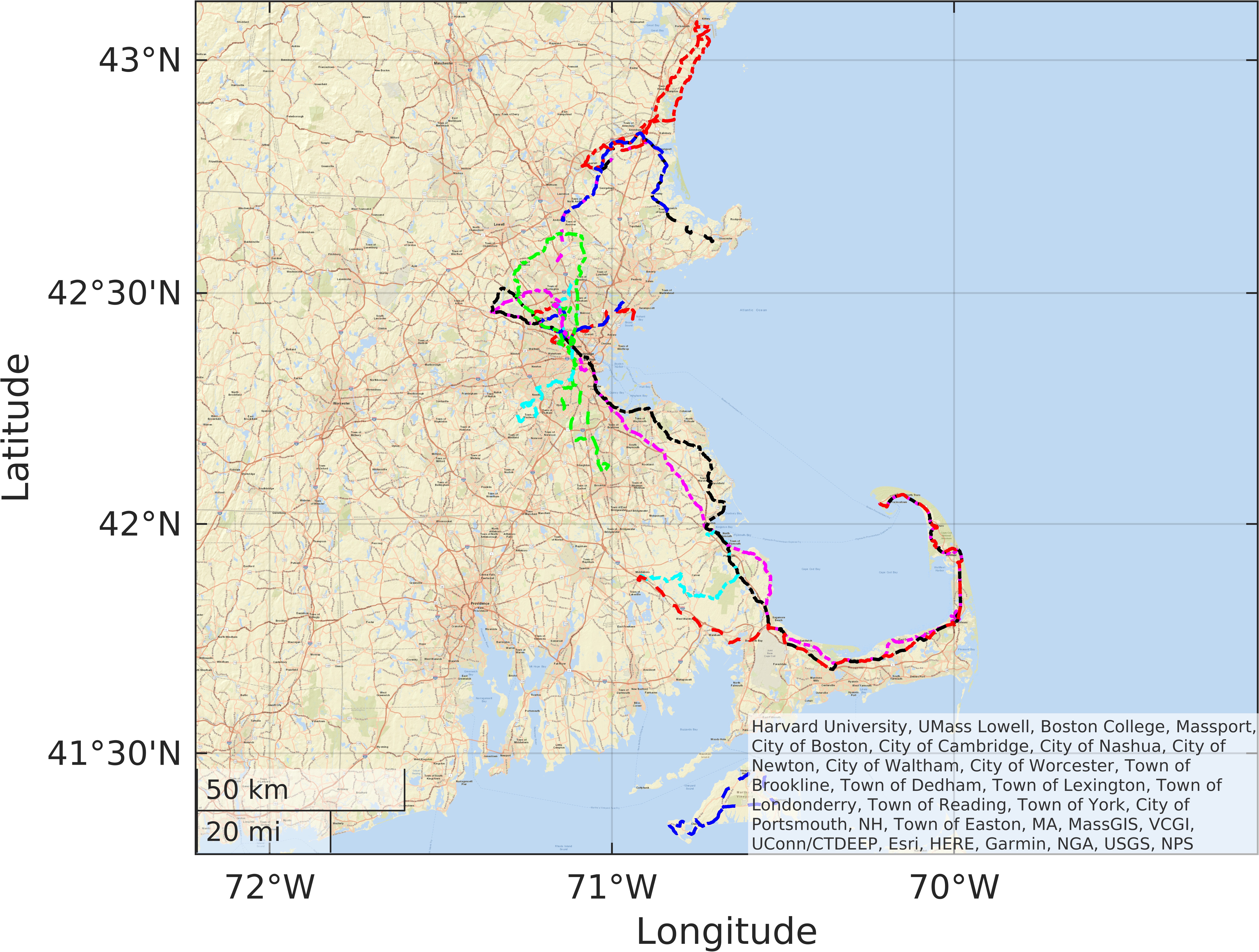
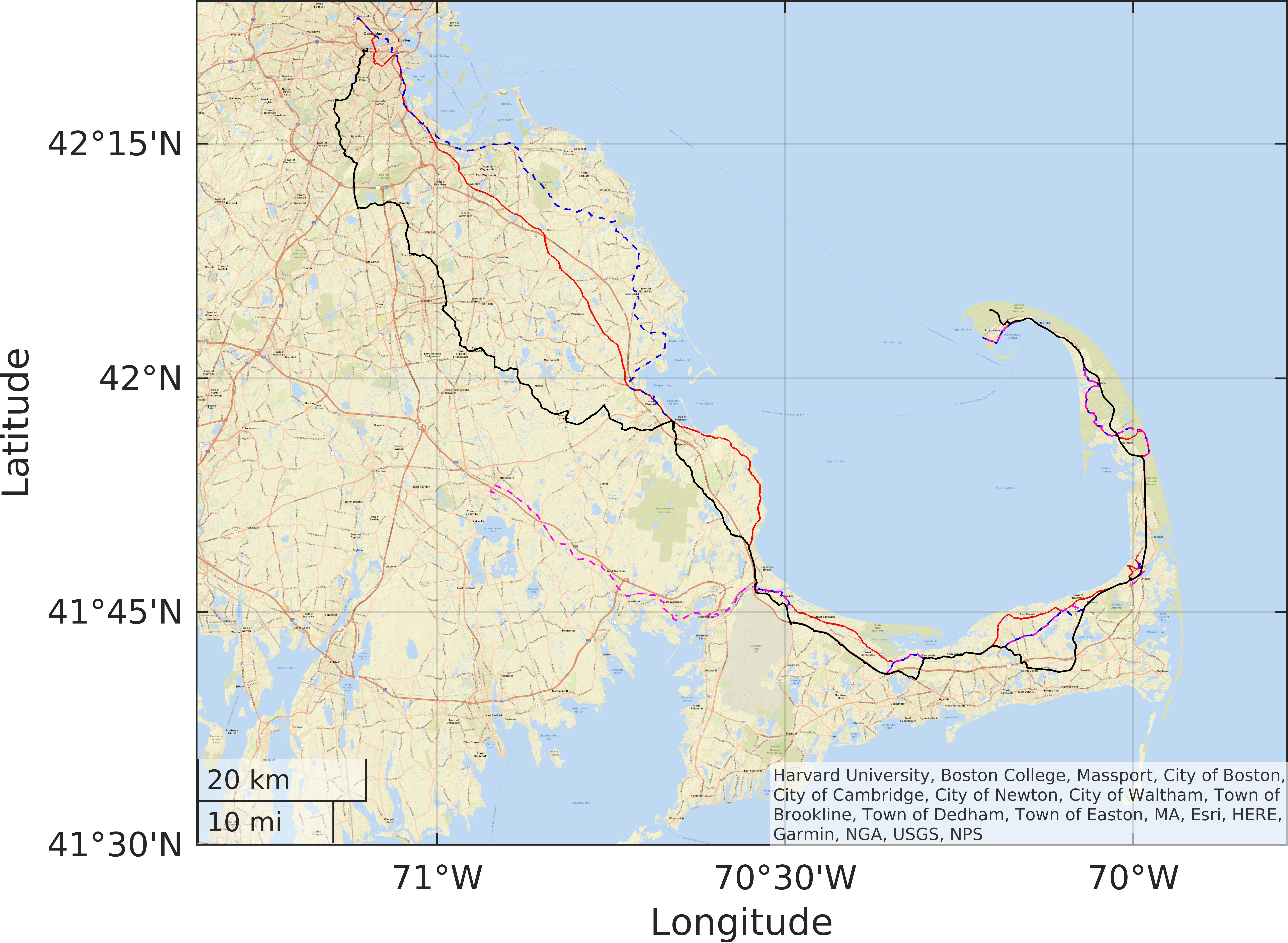
 Tracks are shown in color with different line styles, dash-dash (--) and
dash-dot (-.), with the colors being (r)ed, (b)lue, (g)reen, (c)yan,
(m)agenta, and blac(k). I've tried to produce the maps with good
resolution so you can zoom in to see some of the details. Of course,
using the .gpx files with your own mapping software will give the best
results. All of the files are in the gpx directory.
Tracks are shown in color with different line styles, dash-dash (--) and
dash-dot (-.), with the colors being (r)ed, (b)lue, (g)reen, (c)yan,
(m)agenta, and blac(k). I've tried to produce the maps with good
resolution so you can zoom in to see some of the details. Of course,
using the .gpx files with your own mapping software will give the best
results. All of the files are in the gpx directory.
| Color | Filename | Trip Name | Miles | Elevations |
| r-. | swob-lex20201108.gpx | Russell St. Hill | 24 | Elev 2.54 to 85.21 m |
| b-. | slex-wob20200808.gpx | Whipple Hill | 18 | Elev 7.83 to 117.9 m |
| g-. | shornpond.gpx | Horn Pond | 21 | Elev -6.5919 to 49.1646 m |
| c-. | sreading20200704.gpx | Reading-Woburn | 23 | Elev 1.1 to 80.41 m |
| m-. | s20120421bur_con.gpx | Burlington-Concord | 38 | Elev -9.4758 to 100.5951 m |
| k-. | s20220716concord.gpx | Concord | 33 | Elev 4.94 to 82.33 m |
| r-- | s20220710nahant.gpx | Current Track: 10 JUL 2022 12:06 | 33 | Elev -6.11 to 29.94 m |
| b-- | s20200516lynn.gpx | LynnFlaxPond | 30 | Elev -3.23 to 59.74 m |
| g-- | sbrockton20190704.gpx | Brockton | 54 | Elev 3.98 to 87.14 m |
| c-- | s20210612dover.gpx | Dover Loop | 39 | Elev 3.98 to 108.29 m |
| m-- | sips-nwil.gpx | Ipswich-N.Wilmington | 43 | Elev -102.7238 to 76.0814 m |
| k-- | swglo-hav.gpx | W Gloucester to Haverhill | 39 | Elev -15.2437 to 43.8773 m |
| r-. | s20170722hav-kit.gpx | Haverhill Kittery | 78 | Elev 3.98 to 60.7 m |
| b-. | s20130622ips-ando.gpx | Ipswich to Andover | 39 | Elev -4.6693 to 78.4847 m |
| g-. | s20220605hpsf.gpx | Harold Parker SF | 50 | Elev 1.1 to 90.02 m |
| c-. | scranberry20210926.gpx | Cranberry Ride 21 | 35 | Elev -24.38 to 65.51 m |
| m-. | scc11.gpx | Cape Cod2011 | 135 | Elev -17.1664 to 93.3851 m |
| k-. | scc19.gpx | CapeCod2019 | 140 | Elev -17.65 to 83.77 m |
| r-- | scc21.gpx | CC21on11-12Sep | 98 | Elev -9.96 to 73.2 m |
| b-- | s20170910gayhead.gpx | Gay Head | 46 | Elev -4.19 to 56.37 m |
You currently do not need to get a "Bikes on the T" pass. You will want to have handy access schedules for lines that go into the area you choose. Schedules are on the web at http://www.mbta.com. Remember that you can't take bikes on the T inbound during the morning rush or outbound in the evening rush. The rush hours are indicated on the schedule (I have seen some conductors allow bikes on during the rush, but I wouldn't count on it. The T as an organization is not overly friendly to bikes, but the conductors are very helpful, and riding the train with a bike is a comfortable experience. When you board, go to the conductor on the platform and he/she will direct you to a good location in the car to sit with your bike.
You might also want to get books and bike maps from any local bike store. The bike maps list phone numbers for ferrys, which are good transportation for bicycles. Inter-city buses can also be used, but call the company first, as rules vary. Amtrak is rather hostile toward bikes. You can bring them only on trains with baggage cars, and those are few these days. Train 66 overnight from Washington to Boston and the 67 in the other direction has baggage cars and a sleeper. It is expensive but a great way to travel.
Whatever else you bring, be sure to bring a spare tube, and also a few tools, plenty of water, and a change of clothing. There are plenty of bike shops around, but they may not be opened when you need them, and a flat tire can be a very minor irritation indeed if you have a spare tube and the ability to install it. Water... You can never have too much water. I use a Camelbak with two liters, and there are times when I finish it before finding a place to fill it. Clothing adds weight so don't bring too much, but remember that one of the nicest feelings in the world is that of putting on a clean dry long-sleeved T-shirt when you get on the train feeling a bit chilled, sweaty, and tired, after a day of biking.
Use the technology. Riding the bike is about getting a bit close to nature, but you'll really be glad you had a mobile phone with you when one of your travel companions says, "There are only five of us now and we started with six." Also, a hand-held GPS can clip onto your handlebars. My GPS is a Garmin Etrex Legend, which mounts on the handlebars with an optional mounting bracket, and is great for guiding you and keeping a record of where you have been. There are many options including mobile phones with the same and more functionality. I prepare my tracks ahead of time with a few waypoints to give me an idea of how far it is to the next stop. Many online tools are available to help mange these files. I always save .gpx files locally because some web resources appear and disappear unexpectedly.
More on GPS. I do all my computer work in Linux, and have my own favorite resources.
If you are an engineer or scientist, you may have access to Matlab, which is very good for manipulating and displaying geographic data. I use it to prepare, modify, and display tracks, and used it for most of the work on this page. It's not free, but if you have it, it is a great tool. Important beginner commands are gpxread, geoplot, and geobasemap. It's easy to extract coordinates and compute distances, speeds, etc.
For simple work, I've been known to use a text editor on a .gpx file. The format is quite simple once you get used to it, and using it in combination with mapping software is not hard for someone who is a skilled computer user. The .gpx format is a bit fragile so save backups unless you are very confident.
I find http://www.gpsvisualizer.com very simple to use and you can save a .gpx or other file. Gpsvisualizer has a nice feature in that you can input a url (which could be a link to a Google map, and convert to .gpx. Plan your route with Google maps (use the bike option but then turn off the bike features on the map to show route numbers. For some reason they disappear when in bike mode). Alter the route if you wish. Then click the "link" button to make a short url link to the map. Go to gpsvisualizer, use that link as source, and convert to gpx. You can then save the .gpx file and upload to your device.
Here are a couple of thoughts before you start. Drivers of cars will often be better behaved than you expect. You will hear a horn or two in a trip of 60 miles, but most drivers will either pass you safely or wait behind you until they can get by in the opposite lane. It is best if you make the decision; Claim the whole lane by riding in the middle when you feel unsafe being passed. In most of the towns along the way, there is plenty of food, and we have found restaurant and snack-bar people willing to fill our water bottles, and to provide help with directions. They are not so generous in sharing their potties, however. Any time you have an opportunity to "go," take it! Look at beaches, etc., but don't be surprised if some public rest rooms are locked at all times except the middle of the summer season.
Take the train from North Station to Ipswich. From there you have several options. The one shown on the map ends at the Andover train station for a return to North Station. gpx/s20130622ips-ando.gpx
East Side: Route 1A from Ipswich to Newburyport is wide, quiet, flat, and scenic. The route shows some side streets off of 1A, but the main road is so sparsely traveled, and so scenic, that we didn't take them. Newburyport is a way-too-cute New England seaside town, almost a theme-park replica of itself, but a good coffee stop. You might even consider buying something for lunch later, as food stops are few and limited along the way. On the north end of town, on Water Street just north of State Street, just past all the cute little touristy shops, there is a white wooden building with restrooms where you can refill water bottles. There are restrooms in the basement of the arts center, but the sinks have automatic faucets that only dispense warm water.
The track shown shown goes along the north side of the river. Going out of Newburyport, we continue along Commercial Street to the Chain Bridge. We cross over, and then take the first major left, and follow River Road (be careful of early left turns into local roads) down to Rocks Bridge. There is a portion of the road which is closed to cars, but still open to pedestrians and bikes. You can cross here and go along the south side of the river to Groveland. The route here continues on the north side and crosses into Groveland.
West Side: From there we go down to West
Boxford and North Andover, and into Andover for the train back to
North Station. Eating places are a bit limited, and are mostly
pizzerias. Don't hold out for better food further along the route, as
it really doesn't get any better. There is a ``bad-stuff store'' near
the train station in Andover. Total for the trip is about 42 miles if
you don't get lost. We have also done this trip in reverse, to
accomdate train schedules. It's a bit tricky beteween Groveland and
Andover, and the GPS really helps. This is a nice ride with alternate
stations. In the forward route, you can cut off about 10 miles by
going from Groveland to Haverhill instead of Andover. There are some
nice coffee places in Haverhill near the train station. In reverse,
you can terminate at Newburyport or Rowley.
Alternatives:Here's another variation. gpx/swglo-hav.gpx This one goes from West Gloucester (Remind the conductor to stop, because it is a flag stop. If the train doesn't stop, it's only another 3 miles or so to Gloucester.). This one has easy directions, and plenty of "Plan B" stations. You can end at Ipswich, Rowley, or Newburyport. After that, you are committed to going at least to Haverhill. You can add another 10 miles by continuing to Andover following the Ipswich-Andover route above.
You can add any number
of side trips such as Crane's Beach (Look for Castle Neck on the map),
from a road just south of Ipswich. Get a map and pick almost any side
road going east.
There are a number of roadside eating places along the main route,
including the famous Ipswich Clam Box, a couple miles north of the
center of Ipswich.
gpx/scranberry20210926.gpx This is a relatively flat, 32-mile ride on mostly lightly travelled roads through some very scenic cranberry country. In several places, the road is adjacent to lakes, ponds, cranberry bogs, and other scenic vistas. Start at the Middleboro/Lakeville railhead, (Departs from South Station) and after a couple of miles of rather ugly intersections you will not see much traffic again until you are well into Plymouth near the end of the ride. Just before South Carver, there is a nice sandy-bottom town beach. There are no restrooms or changing area. As you enter Miles Standish State Forest, there are tables for lunch, along with water and rest rooms near the forest headquarters. Heading up into the State Forest, you will find quiet roads with many kettle ponds, including College Pond which has a nice beach with changing facilities, restrooms, and water. You might want to stop at Plymouth Beach, for a quick swim in the Bay. This beach also has restrooms and food. From there, it's a short trip on rather uninteresting suburban roads to the railhead at Kingston. Stop for a snack in Plymouth if you are early; there are no amenities at the Kingston railhead.
This trip is most scenic if you can do it around harves season in late September or early October. Steve and I did this trip in late September 2007, and got to see a bit of the cranberry harvest. Arriving a bit early, we stopped for a while a Plymouth Beach to pass some time before train time. A group of us did it in 2019, and happened to find a few bogs where the cranberries were floating.
This is perhaps one of the most rural of the routes on this page, and there are limited opportunities for food, water, or restrooms. Make sure your bottle is full when you leave Middleboro. The road signs are, like most of those in Massachusetts, a bit sparse. The train schedule is quite sparse on weekends, so plan carefully. With a major swimming stop and a couple of shorter stops we made it comfortably in a total of 4 hours, averaging 12MPH when moving. T
For a beginner, it's an easy ride, but the directions are a bit complicated without a GPS, and there are few alternatives to shorten the route.
gpx/s20170722hav.gpx Here's a chance to ride in 3 states in one day. This is a long ride but relatively flat and many thanks go to Jason for planning it. We ride from Haverhill to the coast, and go up through Rye and Hampton Beach to Portsmouth, NH. It's absolutely irresistable to continue a few more miles across the bridge into Kittery, Maine to say we've actually crossed a second state line for the day. There is food to be had in Portsmouth, along with a nice park for a rest stop. The return is reasonably flat. Dinner can be had in Haverhill while you wait for the return train.
From Brewster or Eastham, we rode the rail trail to Lecount Hollow. I'm told it gets crowded, but on a Sunday morning, it is usually not. It is a fun, fast ride with a few street crossings. Sometimes we stop at Marconi Beach, which requires a detour of about 2 miles each way. There is a bike rack, changing facilities, restrooms, and water, at the beach. There is no food. Lecount Hollow is followed by a bit of a climb which is rewarded with a great view of the ocean. From there we return to the bay side of the Cape on Long Pond Road, which has a nice kettle pond that is another option for swimming, From there we continue for the most part along local roads, stopping for lunch at Jam's in Truro (Other lunch options are in Wellfleet which is a bit early or along Route 6 which will require a small detour), and then route 6 and 6A into Provincetown. We are on Route 6 for only a mile and it is quite wide at this point, so not as scary as it sounds. If you get to Provincetown early enough, you can spend some time at the beaches before returning for the ferry to Boston. Go through town to Herring Cove, which has restrooms, water, and changing rooms with showers. There are many places to eat in Provincetown, and plenty of time for a nice dinner before boarding the boat. Total travel was about 140 miles in 2 days.
This is not a really difficult ride, but it does involve some longer distances, with a few hills, and I would not recommend it for a first ride, simply because "There is no Plan B." If you encounter bad weather, have mechanical trouble, or become tired, there is little choice but to proceed. The intercity busses do not take bikes, it's almost impossible to get into a hotel room on short notice, and there are few other transportation alternatives. Recently, a local bus service has started on the Cape, from Barnstable to Provincetown, and these busses have bike racks, so it might in fact be possible to get to the boat at Provincetown from somewhere along the route. Nevertheless, if you have doubts about your ability to finish the trip, it would be wise to start with another trip. We encountered Hurricane Charlie in 2004. After waiting out the worst of it, we shortened the route a bit by using US Route 6 from Lecount Hollow to North Truro. That saved perhaps 4 miles (and maybe a few hills). In 2015 we had rain all the way, and we had a few sprinkles other times, but except for these two trips the weather has been mostly good.
Check with Bay State Cruises for ferry service from Provincetown to Boston. Reservations are recommended.
This trip actually works best with a car. Drive to Woods Hole. Ignore the first sign for ferry parking and park downtown. They save some spaces in the downtown lot for cars carrying bikes so you don't need to do the longer bus ride from the remote lot. On our first trip we didn't know this and lost a lot of time. Plan extra time the first time you do this. Plan to take the early morning ferry out of Woods Hole to Oak Bluffs. From there, we took the North Road and Lambert's Cove road down to Menemsha. There are several places for lunch, ranging from deli to clam shack. There is a small bike ferry ($6.00 per bike, 6 at a time as of 2019). Ask anyone in Menemsha where to get the bike ferry. It runs on demand during the day, and is a very short ride. We rode around to the Gay Head light, climbed to the top of the light, and rode back up the Middle Road, around the airport, and back to Oak Bluffs. Total distance here was about 45 miles. Then, we caught the evening ferry back to Woods Hole for dinner, and drove home fairly late at night.
If you do want to do this without a car, you may want to take
3 days with one for the Vineyard and one each for riding to and from
the Cape. You can find lodging in Falmouth, and there is also a
ferry from there so you don't need to go to Woods Hole. In the
summer you can also take the Cape Flyer train to Hyannis and get a
ferry from there instead, but I am not sure it can be done in one
day. Remember that the Cape Flyer only runs during tourist season.
The ferry from Woods Hole is operated by the Steamship Authority, a
state organization, and has the lowest prices. Ferries from
Falmouth, Hyannis, New Bedford, and elsewhere are private and more
expensive.
Here are some short to medium-distance trips that do not reqire the use of the trains. It's a bit of a challenge to get out of the city without a lot of traffic, but there are some reasonable routes. Most of these start and end in Cambridge, but there are a couple from the area around Jamaica Plain and Forest Hills.
gpx/s20220605hpsf.gpx. This ride is a bit longer, at 50 miles or so. You might want to bring a lunch for this one, as there are not many places between Readinng and Billerica. The trip through Stoneham and Reading has quite a bit of traffic, but you could instead ride up through Woburn, following the Reading/Woburn route gpx/sreading20200704.gpx in reverse partly along Washington Street. Shortly after a fire station in Reading, you bear right toward North Reading and begin a more relaxed ride up through the Harold Parker State Forest. I crossed over along a road that is closed to traffic to get to the Berry Pond area. Heading west, we pass through Ballardvale, and out onto Shawsheen Road for the ride down to Billerica. From there we go to South Billerica and make a left turn onto Springs Road, which goes through the Bedford VA Hospital campus and out into Bedford for an easy ride home on the Minuteman Rail Trail. A stop at MA-France for espresso and a pastry is a highlight of any ride on the Minuteman.
gpx/sreading20200704.gpx A fairly short ride up to Reading and back through Woburn and down along the Mystic Lakes can be done in a couple hours. The ride through Stoneham and Reading is a bit busy and unpleasant, but the rest of the trip is more relaxed and has some nice scenery. gpx/s20220716concord.gpx A standard afternoon ride uses the Minuteman Rail Trail to Bedford, then crosses the Concord River to go through some farm land on the north side and into Concord. The Trail's End Cafe is a nice lunch stop slightly off the track in Concord. We return by Lexington Road and Marrett Road, mostly along or close to some historic sites from the Revolutionary War, and usually end with a stop at MA-France for espresso and a pastry. gpx/s20120421bur_con.gpx A longer ride takes us up along the Mystic Lakes past Horn Pond and into Woburn. There's a steep climb up Center Street to a park in Burlinton for a much-needed rest. After that we head to Bedford, joining Route 62. You can return on the Minuteman Rail Trail, or continue on to Concord either on 62 or on the north side of the river as in the above trip.
gpx/s20210612dover.gpx This loop was suggested by the MIT road-biking site, it's mostly a nice route with some traffic here and there, and a few good hills near Dover. It's possible to cut off some of those to reduce the distance. Food is a bit sparse so this may be another ride where packing a lunch is recommended.
gpx/shornpond.gpx This is a short scenic ride up the Mystic Valley. We ride along the Mystic Lakes. You may want to stop at the Mystic Lakes Dam between the two in West Medford for the view, or take a swim at Shannon Beach on the northern end of Upper Mystic Lake. It gets crowded at the usual times, but is a nice sandy beach. For variety, use Grove Street out of West Medford instead of the Parkway. Rather than ride up Route 38, turn left on Palmer Street and immediately turn right on the Horn Pond Bike Trail, which follows part of the old Middlesex Canal. Look to your right for some views of the canal. You can ride all the way around the pond on paved roads (stay close to the pond on the west side). Lock your bike and hile up the hill for a nice view of the city. You might also find some concrete pads which were part of the lift system of a small abandoned ski area.
gpx/swob-lex20201108.gpx This one is basically a good chance to work on your hill-climbing ability. Ride out past Horn pond and head toward Lexington along Pleasant Street and Russell Street. The hill after crossing Route 3 always gives me a good challenge early in the season. The return is along the Minuteman Rail Trail, and the whole trip can be done after work in the summer when the days are longer.
gpx/slex-wob20200808.gpx. This is a slightly shorter hill trip. We ride to Lexignton and take Maple Street to the right off Massachusetts Avenue. If you use the Minuteman Rail Trail, Maple Street crosses on an overpass so you will miss it. Check the map to get out to Massachusetts Avenue before or just after that overpass. There's a good climb up Whipple Hill and a trailhead where you can stop for a rest. Then it's down into Winchester across Route 3 onto Wildwood Road, where you can pick up part of the Horn Pond Route for the return.
Starting on the Horn Pond route, you can also travel around the outer edges of the Middlesex Fells. The interior of the park is mostly dirt and very nice on a bike with big tires, but the roads around the outside are paved and will give you a couple of hills. Most of the route follows roads that are lightly traveled by cars, and have wide enough shoulders. There are a number of variations on this trip to explore, going further to the east, out near the Stone Zoo, etc. There are commuter rail stations in Winchester, Melrose, and Medford, for the beginners, who want to shorten the trip.
This Page Copyright (C) 01999, 02005, 02007, 02008, 02022 by Charles
A. DiMarzio. This page is Y-10k compliant.